MapToaster Mobile V3.0 Upgrade
New in MapToaster Mobile/NZ V3.0 for your GPS:
- Almost 150 map sheets have been updated since version 2.0 (and lost more if you're still on V1.0). LINZ updates up to Arpil 2013 are included, with many improvements to DOC track and hut features.
- Updated search index - with DOC track and walkway start/end points as well as food, fuel, money, accommodation, airports
- Offshore islands - Snares, Auckland, Campbell, Antipodes, Bounty, Chatham and Kermadec Is are included
- Updatd National Park and comprehensive public Conservation Land boundaries
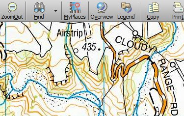
The maps have the same familiar cartography of the paper maps with clear track markings.
 |
Rich information. When you tap on a point on the map on a touch-screen or press ENTR on a keypad style GPS, you get a list of the features under the point. In this example you can see Mt Misery summit (924m) has scrub ground cover, is inside the Totara-Mikonui Conservation Area, in the Totara River locality.
 |
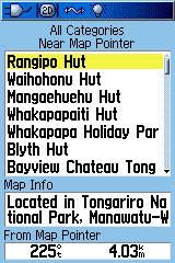
The POI search index has DOC tracks and walkway start/end points to make it easy to find the start of your walk. Just search for "tk" in the All POI index to find nearby tracks start/ends.
 |
MapToaster Topo/NZ for PC Included
As with V2.0, MapToaster Mobile/NZ Version 3.0 includes a copy of MapToaster Topo/NZ for your computer. This provides high-quality maps for your computer that look identical to the printed LINZ topo maps, as well as easy to use software. When you upgrade, you get an upgrade to MapToaster Topo/NZ V6.0 as well.
There are two options for MapToaster Topo/NZ, High-resolution and Standard Edition. The high-resolution maps have twice the resolution of the Standard Edition and give the sharpest and clearest prints. The MapToaster Mobile/NZ maps are the same, regardless of which edition you choose for your PC.
The upgrade package includes
- MapToaster Mobile/NZ upgrade DVD. Automatically upgrades your version 1.0 or 2.0 microSD card to version 3.0. Requires a microSD-to-USB adapter to plug your card into a PC. Can also upgrade the card when installed in Garmin Oregon, 62s or Dakota GPS.
- A copy of MapToaster Topo/NZ V6.0 maps and software for your PC (Std or High-res PC maps, depending on the version you currently have.)
- Note that MapToaster Mobile/NZ V3.0 does not include a CD-ROM for use with MapSource.
Find Out More
- Read the FAQ
How to Upgrade
We'll be sending out upgrade emails in Aug 2013. If you haven't heard from us (first check your spam folder) and you would like to upgrade to version 3.0, email us at with your serial number, or if you can't find that we can probably locate your details from your email address .
Garmin, eTrex, Oregon, Dakota, Colorado and Nuvi are a trademarks of Garmin Ltd. These maps are not Garmin products and are not endorsed by Garmin Ltd. MapToaster is a registered trademark of MetaMedia Ltd. Selected POI data was kindly made available. by Zenbu. Neither Integrated Mapping, MetaMedia Ltd or the data suppliers warrant that the maps are free from errors or omissions. Some data source from LINZ, NZ Fire Service and DOC - Crown Copyright.
Frequently Asked Questions
GPSMAP 62s Review
Our review of the GPSMAP 62s GPS
Geocaching
An introduction to geocaching Geocaching
Choosing a GPS
Some thoughts on buying a buying a GPS
NZTM Projection
The new New Zealand Transverse Mercator (NZTM2000) map projection
How GPS Works
Quick intro to how GPS works
Find
Find works anywhere in New Zealand, not just near to where you
are. When you select an entry in the top box, the next box down shows the locality name of the point and the bottom box shows the direction and distance.
You can also find roads anywhere in the topographical road network.
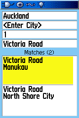
Select a combination of region, city and road name. The bottom box shows the list of possible matches.