Garmin GPSMAP 62s Review
The Garmin 62s is an update of the GPSMAP the 60CSx, one of the most popular outdoor GPS units. The unit features a new case design, updated hardware. The updated firmware adds features like the ability to load aerial photography and do paperless grocaching.
The unit highlights are:
- microSD slot and substantial internal memory
- rugged, IPX7 waterproof case
- high-sensitivity receiver
- 3-axis, tilt-compensated electronic compass
- barometric altimeter
- paperless geocaching
- USB, serial and external antenna connectors
- improved 160 x 240 pixels 65,000-colour screen
Hardware
The photo below shows the 62s (right) compared with a GPSMAP 60CSx.
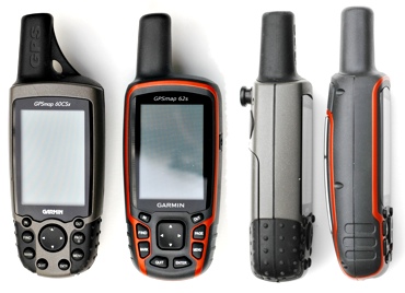
The 62s is a millimetre or two larger than the 60CSx and about 50g heavier. The screens are almost the same size, and they both have 160 x 240 pixels.
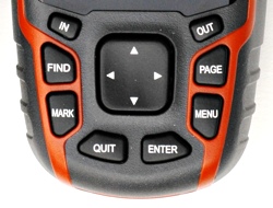
The GPS is controlled using a rocker arrow button and 8 function buttons. IN/OUT zoom the map and altimeter views in and out. FIND takes you to the location search pages. MARK creates a new waypoint. MENU, ENTER, and QUIT are used together with the rocker to navigate the unit's menus. PAGE moves you between the units different screens, map, altimeter, setup menu, trip and so on. This layout is the same as the 60CSx.
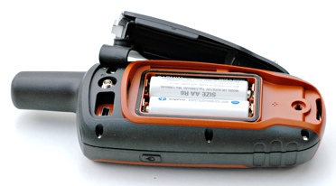
The back of the unit has a hard detachable battery cover. Rotating the metal clip releases the cover, for changing batteries. Like many other Garmin models, the slot for the microSD data card is under the batteries. The retaining clip is a little bit fiddly and you need to take care it doesn't pop open if you are changing batteries in the field.
Also on the back is a mini-USB connector and MCX connector for an external antenna. A rubber cover protects the connectors. The external antenna connector provides the option of using the unit in a vehicle or boat, where there is no clear view of the sky.
Like the Oregon series, the battery cover has the rail for attaching a carabiner, or attaching the unit to a car, boar or bike mount. Using the metal clip on the battery cover for a lanyard is not a good idea as it can pull the battery cover open and the GPS falls off.
The power button is on the side of the unit. To turn the power on/off hold the button down for several seconds. Pressing the power button briefly opens a page with the battery and signal strength indicators and the backlight brightness control. Pressing the power button repeatedly gives coarse adjustment of the brightness, while the rocker arrow buttons give fine control.
Claimed battery life is similar to the 60CSx and better than either the Oregon or Colorado. The Garmin manual says up to 20 hrs. With 2000 mAh NiMH batteries I was getting 14-16 hrs of reasonably heavy use. How much you use the backlight, redraw the maps and have the compass turned on etc will have a big effect on battery life.
The 62s uses a high-sensitivity GPS chipset. Unscientific tests under challenging conditions gave similar results for the 60CSx compared with the Oregon and Colorado. The time to the first position fix was similar to the other units. The receiver really is extremely sensitive. You can expect it to work in all but the most challenging situations. You can get a fix under dense canopy, amongst high-rise buildings, in a car and often inside buildings.
The GPS has a tri-axial compass. This means it doesn't have to be held level. The compass needs to be recalibrated when that batteries are changed.
For use in the car, there is a car kit with a suction windscreen-mount and a special lighter power cable that plugs into the mini-USB port on the unit. The rail mount system is easy to use and works well. There are also bike and marine mounts.
Screen
The 62s screen is 41mm across and 56mm tall. The Oregon and Colorado screens are 38mm x 63mm. Physically, the difference is not great, but the Oregon and Colorado have a much higher pixel density. The Oregon screen has two and a half times as many pixels in its display. Like the Oregon and Colorado, the 62s can display 65,000 colours, compared to the 256 of the 60CSx.
This difference in the pixel density is hard to convey on a computer screen. The first image below is a screen capture from an Oregon. The second is from a 62s and has been enlarged to reflect the relative physical size of the screens on the two units. On your computer screen, these images will be bigger than on the actual GPS.
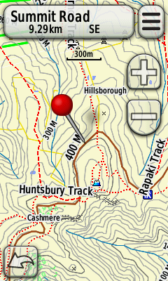
Oregon Map Screen Capture
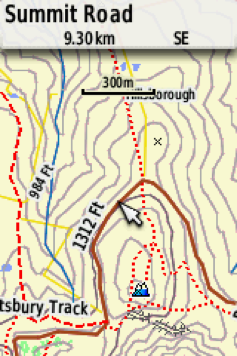
62s Map Screen Capture
As you can see, the Oregon/Colorado display shows two and a half times as much map at a given zoom level. However, don't let that put you off the 62s as the mapping is quite usable.
The GPS worked fine in all the lighting conditions that we tried. In bright light, the screen was more visible than the Oregon 300 we used for comparison.
User Interface
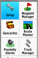
The user-interface is easy to use and learn. The 8 buttons and rocker arrow pad give you access to the GPS functions. The functions are organised into a series of pages, main menu, map, trip computer, compass etc. About 15 pages in total. These pages are accessed either from the main menu, or in a sequence of pages that are displayed when you push the PAGE button.
|
|
|
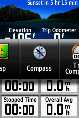
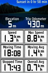
The Trip screen shows comprehensive information on your position and travels. The data displayed on each position on the screen can be customised. You can select the value to be shown from a large list of data like speed, distance, position etc. There is also a big print option with fewer values. This is great for use in a vehicle.
 |
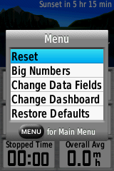 |
Trip Computer Screen
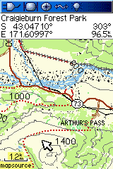
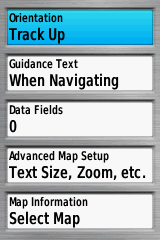
Similarly, on most pages, further functions for that page are accessed by pressing the MENU button. There are a great many options allowing you to customise the device just the way that you want it. Here are the map options.
 |
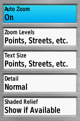 |
Map Setup
The above examples show the options for customising the map. Almost every aspect of the map display can be setup the way that you want.
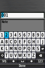
Text entry is servicable, but not as easy as the Oregon touch-screen. When you need to enter text for a search or a waypoint etc, a keypad pops up on the screen. To enter text you move the yellow highlight to the next letter or number to enter, using the rocker pad. Then enter the key with the ENTER button. Once your entry is complete you select the "OK" button on the keypad.
While the full-screen touch keypad on the Oregon is much faster to use, unless you capture a lot of waypoints, does it matter that much?
Maps
There are a wide variety of maps for this unit. For outdoor activities, topo maps, such as our MapToaster Mobile/NZ provide detailed topographical mapping. The 62s also supports shortest-path street navigation, with suitable maps. Garmin provides City Navigator maps for this. For marine use there are the Garmin BlueChart series.
To use multiple map sets you can change microSD cards. If you have CD/DVD versions of the maps, composite maps sets can be loaded onto a single card using Garmin MapSource software.
Find
The FIND button takes you to the screen that lets you search waypoints, placenames, addresses and points of interest (POI).
When you press the FIND button you see the screen below.
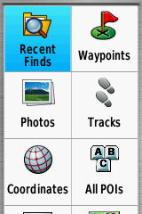
Find Screen
The 62s has excellent Find tools. Select a category icon, e.g. "Geographic Points". The GPS will display all the points in the selected category in a list, starting with those closest to you. This can be useful for finding, say, the nearest petrol station or hut or ATM.
To search for a particular item, press the MENU button. When you eneter partr of a name to search for, the GPS searches nearby for names that contain the text you entered, anywhere in the name. For example, if you enter "hut", the GPS will show a list of all the POI with that string in it, e.g. "Hutt River" and "Greenpark Huts" would be both be resulst of this search.
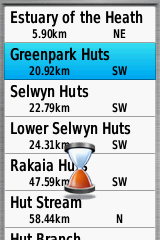
Finding a Hut
Once you have found what you are looking for in the find list, use the rocker pad to select the item and press the ENTER button. You will see the screen below. This contains a map and additional information about the location.
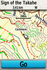
Location Selected
Storage
The 62s can store a lot more, tracks, waypoints and maps than the 60CSx. There is 1.7GB of built-in memory for maps and tracks. The unit can have 200 saved tracks, up from 20, 200 routes, up from 50 and 2000 waypoints, up from 1000.
The GPS can also display limited amounts of raster mapping or aerial photos. You can load Garmin Birds-Eye imagery, or load sections of topo maps or aerial photography from our MapToaster Topo/NZ software. Regardless of the amount of free storage, the imagery that can be loaded is limited to about one Topo50 map sheet, or about a quarter of a map sheet of the MapToaster Topo/NZ aerial photography. This is a limitation of the device, not the amount of free storage.
Connecting to a Computer
You can connect the computer using a mini-USB cable. The GPS uses the same "mass storage" approach as the Oregon series, where the GPS shows up on your PC as a new drive letter, or on a Mac it shows on the desktop as a new drive. If you have a microSD card fitted, that will show up as a second drive.
You can use software, such as our MapToaster Topo/NZ or Garmin BaseCamp to copy tracks and waypoints to/from the GPS. The GPS also stores its tracks and waypoints in a folder on its drive called \Garmin\GPX. The tracks and waypoints on the device can be found in GPX files in that folder and if you save a GPX file to that folder, it's added to the collection on the GPS
Realtime tracking is also available in NMEA mode.
Summary
The 62s updates the well proven 60CSx GPS. It has improvements all round over the earlier model.
Should you get a 62s or an Oregon? Both of these are great units and you are unlikely to be disappointed by either. For hard-core outdoor use, expecially if you are a professional, the balance probably tips in favour of the 62s. If you plan on using the GPS for a mix of activities, e.g. tramping, geocaching and in-vehicle, the Oregon might suit better.
If you're thinking of buying a GPS, take a look at our guide to buying a GPS
Other Resources
The User Manual is available for download from Garmin.
Check out our other reviews
And also the article on choosing a GPS
Any Questions?
If you have any comments, or there's anything you'd like to know about the 62s I haven't covered, and I'll add it (BTW, we don't sell GPS units).
JM - Feb 2011
Copyright © 2011 Integrated Mapping Ltd. All Rights Reserved. This article may not be reproduced without permission. Garmin is a trademark of Garmin Corporation.
