NZ Topo Maps for Your Garmin GPS
MapToaster Mobile/NZ is premium topographical mapping of New Zealand for Garmin® GPS. The only package with:
- detailed topo maps with the familiar cartography of the LINZ 1:50,000 series maps
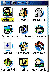
- travel related POI - DOC track and walkways, food, fuel, money, accommodation, airports
- 8GB microSD card and SD adapter and maps for your PC included as standard
- locality names aligned with those used by government, emergency services and NZPost
- offshore islands
- National Park and comprehensive conservation land boundaries
- Included Topo50 updates to Nov 2024
- For use with 60CSx, 62, 62s, 64, 66, eTrex, Oregon, Dakota, Colorado, Montana, Rino, Astro, and Nuvi series mapping GPS units. Also supports newer models like the 67 with the MTP interface. Check the FAQ for more detail.
- software and maps for your PC included
- incredibly friendly and helpful technical support
 |
Whether you are into tramping, climbing, hunting, 4WD or commercial outdoor activities, you'll always know exactly where you are with MapToaster Mobile/NZ topographical maps for Garmin outdoor mapping GPS.
The clean map design, with maximum information and minimum clutter, follows the familiar cartography of the LINZ 1:50,000 maps.
Almost all the detail on the paper topomaps is included, with dozens of map feature types, including waterways, lakes, tracks, huts, 20 metre contours, natural and manmade ground cover, fencelines, roads, railways and buildings. The locality and suburb naming is aligned with government, emergency services and NZPost locality names. "Mouse over" shows the locality name when there is no other landcover.
The maps cover mainland New Zealand, Stewart Island, Auckland Is, Campbell Is, Snares Is, Antipodes Is, Bounty Is, Chatham Is and the Kermadecs.
 |
 |
In addition to the usual geographic placename search, we have added a selection of fully searchable points of interest (POI) useful when you're travelling. You can use the map to find the nearest food, fuel, money, accommodation, airports, railway stations etc. There is a comprehensive hut list that was collated from various sources and includes both DOC and non-DOC huts. You can also search for the start/endpoints of DOC tracks and walkways.
MapToaster Mobile/NZ makes a perfect complement to MapToaster Topo/NZ topomaps on your PC.
The package includes
- 8GB microSD card with the maps pre-loaded. Just put the card into your GPS and go - nothing to install. Can be used with 60CSx, 62, 62s, 66, 67 eTrex, Oregon, Rino, Colorado, Magellan, Astro and Nuvi mapping GPS - see the FAQ for supported GPS units
- MapToaster Topo/NZ maps and software for your PC (Std or High-res map options)
- SD card adapter for use with units like the Nuvi
Find Out More
 |
Garmin, eTrex, 60CSx, 62, 62s, 64, eTrex, Oregon, Dakota, Colorado, Montana, Rino and Nuvi are a trademarks of Garmin Ltd. These maps are not Garmin products and are not endorsed by Garmin Ltd. MapToaster is a registered trademark of MetaMedia Ltd. Selected POI data was kindly made available by Zenbu.
Frequently Asked Questions
- Do I Need a Map Update to use Topo50 NZTM Maps?
- Which GPS Units are Supported?
- Do the Maps Look Like the Paper Topomaps?
- more>>
New
MapToaster Mobile/NZ V14.0
is now available, with updated maps. More...
New
MapToaster Topo/NZ V14.0
is now available, with updated maps and aerial photos. More...
MapToaster for iOS
MapToaster for iPhone and iPad now with Spring 2024 maps, including mainland New Zealand, Chatham Islands, Raoul Island & Kermdec Islands, Auckland Island, Campbell Island, Snares Island, Antipodes Island and Antarctica in the Ross Dependency area, check it out.
GPSMAP 62s Review
Our review of the GPSMAP 62s GPS
Geocaching
An introduction to geocaching Geocaching
60CSx Review
Our review of the GPSMAP 60CSx GPS
Choosing a GPS
Some thoughts on buying a buying a GPS
NZTM Projection
The new New Zealand Transverse Mercator (NZTM2000) map projection
How GPS Works
Quick intro to how GPS works
Oregon Review
Check out our review of the Garmin Oregon 300 & 550 GPS
And our review of the Garmin Colorado 300 GPS
Ask a question
Want to know more?
Find
Find works anywhere in New Zealand, not just near to where you
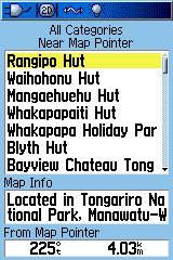
are. When you select an entry in the top box, the next box down shows the locality name of the point and the bottom box shows the direction and distance.
You can also find roads anywhere in the topographical road network.
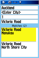
Select a combination of region, city and road name. The bottom box shows the list of possible matches.